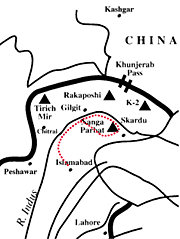

|
| |
Islamabad |
| |
Besham |
| |
Gilgit |
| |
Astore |
| |
Tarashing |
| |
Rupal |
| |
Harligkoffer
Base Camp |
| |
Latobah |
| |
Shaigiri |
| |
Mazeno
Base Camp |
| |
Mazeno
High Camp |
| |
Mazeno
Pass |
| |
Laibh
Meadows |
| |
Zangot |
| |
Zangot
Rest |
| |
Shaichi |
| |
Gutum
Sagar |
| |
Jalipur
High Camp |
| |
Beyal |
| |
Fairy
Meadows |
| |
Chilas |
| |
Islamabad |
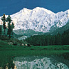
Nanga Parbat (8125 m.) is the western most bastion of the Himalayas.
One has to travel completely around the globe to come back to the Himalayas to
see such high peaks on our planet. The word 'Nanga' means naked and 'Parbat' is
mountain.
This immense massif made a never-to-be-forgotten childhood impression
on us. Masood saw this peak rising into the heavens when he was only five years
old! It is a sight that is as vivid as it was then; 35 years ago.
Nanga
Parbat is also a killer mountain. Many climbers died on it before it was summited
by the great Hermann Buhl without supplemental oxygen in 1953. His epic climb
is still unsurpassed. We are honored to say that it was at our uncle's clinic
in Lahore where Hermann Buhl came to recuperate and was treated for his death-like
state.
Nanga Parbat is also located where the continents have collided.
Here the Indian plate is going under the Asian plate at a rate of about few inches
a year. Consequently, Nanga Parbat is still rising. In fact it is the fastest
rising mountain in the world!
This is a land of superlatives. The view
of Nanga Parbat from the Indus River is one of the most awesome sights in the
world. This largest land escarpment in the world consists of a rise of about 7000
m. from the base of the mountain to its summit. On the other side of Nanga we
have the famous Rupal Face; the tallest wall in the world with a sheer 4500 m.
cliff!
The journey traditionally called: 'Around Nanga Parbat' actually
goes halfway around the mountain. It offers us stupendous sights of this Himalayan
giant. The crossing of Mazeno Pass (5,399 m.) is a technical endeavor where ropes
are fixed on steep pitches. The trip is for anyone who wants to get close to this
legendary mountain and feel its presence deep down in one's soul! This is a challenging
trek in Pakistan's Himalaya.
Day 1, Rawalpindi/Islamabad
Hotel,
trek briefing. We will have ample time for sightseeing and shopping in colorful
old bazaars of Rawalpindi and new markets of Islamabad. We may also drive to the
huge modern Faisal Mosque in Islamabad.
Day
2, Besham
Hotel, drive. We will drive on
the famous KKH to Besham through Taxila and Abottabad. Time permitting we will
stop at the famous Gandharan archeological sites in Taxila. We will drive up the
lush green foothills of the Himalayas and cross the mighty Indus near Besham.
It will take about 6 to 8 hours to drive to Besham.
Day
3, Gilgit (1,500 m 4,920 ft)
Hotel, drive.
It takes about six to eight hours to drive from Besham to Gilgit. The drive through
the Indus Gorge is guaranteed to knock your socks off! The view after crossing
the Rakhiot Bridge of Nanga Parbat is without any parallel. Standing at around
1,000 m. you see a mountain which rises to above 8,000 m.! This is the largest
land escarpment in the world. This is also where the three greatest mountain
ranges meet; Himalaya, Hindukush and Karakoram. We will have time to shop in
the Central Asian bazaars of Gilgit.
Day
4, Astore (2,350 m 7,700 ft)
Camp, jeep
drive. We will backtrack our route from Gilgit and take a left hand turn on the
KKH near Jaglot to enter the Astore valley. It takes about 6 to 8 hours to get
to Astore town. We will camp in Astore.
Day
5, Tarashing (2,900 m 9,500 ft)
Camp, jeep
drive. After about 3 to 4 hours of rough jeep driving we reach the village of
Tarashing in the Rupal valley. Here we send our jeeps back to Gilgit. The Rupal
valley is a beautiful forested valley with many pine trees.
Day
6, Rupal (3,200 m 10,500 ft)
Camp, trek.
The trek begins. We walk through lush and gentle fields and cross the snout of
the Tarashing Glacier. The walk only takes about 2 to 3 hours. If we feel fit,
we can go to the next camp (Herligkoffer Base Camp) or just relax at Rupal.
Day
7, Herligkoffer Base Camp (3,600 m 11,800 ft)
Camp,
trek. Another 2 to 3 hours of walking brings us to this beautiful meadow campsite.
Our camp is located near some springs and at the edge of the Bazhin Glacier. We
start seeing views of Rakhiot Peak and Chongra Peaks of the Nanga Parbat massif.
Day 8, Latobah (3,650 m 11,970 ft)
Camp,
trek. In about 2 to 3 hours of walking we will reach this famous campsite right
under the largest wall in the world; the Rupal face of Nanga Parbat. The wall
rises about 5,000 m. to the summit of this great mountain. On the way we cross
the Bazhin Glacier.
Day 9, Shaigiri (3,700
m 12,140 ft)
Camp, trek. This takes about
4 to 5 hours of trekking. On the way will cross the snout of the Shaigiri Glacier.
From Shaigiri we will also have awesome views of the Rupal face of Nanga.
Day
10, Mazeno Base Camp (4,000 m 13,120 ft)
Camp,
trek. After crossing mountain streams and leaving the woods and pastures behind
we enter the high meadows of the Mazeno valley. This takes about 3 to 5 hours
of walking. Here we have outstanding views of Mazeno peaks.
Day
11, Mazeno High Camp (4,700 m 15,400 ft)
Camp,
trek. This is a tiring day. It takes about 5 to 7 hours of steep hiking up the
hill and the camp is located near the Mazeno Glacier.
Day
12, Laibh Meadows (4,200 m 13,780 ft)
Camp,
trek. A tough day! This is the apex of the walk. We will ascend Mazeno Pass (5,399
m.) and descend very steeply on the other side. The ascent is easier than the
descent. Ropes will be fixed on the descent on 35% plus slopes. As always, we
will be assisted by the staff. This will take about 8 plus hours.
Day
13, Zangot (2,700 m 8,850 ft)
Camp, trek.
This takes about 6 hours of walking. We enter a land inhabited by people and walk
through pastures. The day is long and involves an exhaustingly steep descent.
However, it is not technical as the descent from the Mazeno Pass.
Day
14, Zangot Rest (2,700 m 8,850 ft)
Camp.
Here we enjoy the much needed rest!
Day 15,
Kutagali (3,000 m 9,840 ft)
Camp, trek.
This takes about 4 to 5 hours and we walk along paths used by herders to reach
their summer settlements.
Day 16, Shaichi
(2,900 m 9,500 ft)
Camp, trek. In about
6 hours and after crossing the non-technical Karu Sagar Pass (4,900 m.), we reach
another summer settlement called Shaichi. The Diamir face of Nanga overwhelms
us continuously.
Day 17, Gutum Sagar (3,500
m 11,480 ft)
Camp, trek. We are now walking
through forest and summer pastures. We will cross some streams on this leg of
the trip. This takes 6 hours plus of walking.
Day
18, Jalipur High Camp (4,300 m 14,100 ft)
Camp,
trek. We have an ascending walk for about 6 hours and have good views of Jalipur
Peaks.
Day 19, Beyal (3,400 m 11,150 ft)
Camp,
trek. Today we will cross the non-technical Khutsu Pass (4,840 m.). From the top
of the pass Nanga is seen once again. The steep ascent to the pass takes about
3 hours and the descent to Beyal is done in about 5 hours. At Beyal we camp next
to the Rakhiot Glacier.
Day 20, Fairy Meadows
(3,200 m 10,500 ft)
Camp, trek. Congratulations!
We have circumnavigated the great Nanga Parbat. This is an easy 2 hour walk through
pine forest and incredible views. The sight of the north face of Nanga will never
leave you!
Day 21, Chilas (1,000 m 3,280
ft)
Hotel, jeep. Our jeeps will be ready
to take us from the end of the road near Fairy Meadows. It is about 2 to 3 hours
of driving down into the Indus gorge towards Chilas.
Day
22, Rawalpindi/Islamabad
Hotel, about 8
hour drive on KKH, trek debriefing.
Day 23,
Rawalpindi/Islamabad
Extra cushion day!
Note: Day 23 will be used as a cushion day in case of delays in travel due to weather,
route change, health, acclimatization issues during the trek, etc.
This
is a tentative itinerary. For the enjoyment of your trip a go with the flow
attitude is necessary. Many factors will influence your trip, such as weather
conditions, health, route conditions, etc. Please do not take this itinerary
very seriously! |